Day 7
Waking up alone this morning in Gretna and enjoying breakfast with my parents still seems so wrong to me. I mean, in Gretna in sight of the Marriage Room with only your parents for company, its so wrong.
At breakfast, a quick calculation reminded me that I have now done over 500 miles this week.
Late last night, I decided to revise my route. Instead of the planned ride today from Gretna to Mauchline (near Kilmarnock) along the A75 in favour of riding up the old A74. When the A74M was opened, the old road which ran nearly parallel to it remains in place, being numbered the B7076 and later the B7078. This proved to be a good choice. The rod was long and straight and virtually deserted. In the 18 or so miles to Lockerbie, we probably did not see 100 vehicles in either direction. It was windy, but mainly a tailwind, so this counteracted the cold and the real threat of rain. The Met Office had issued warnings re the heavy rain expected across most of the UK today.
We stopped in Lockerbie for a cup of tea and then set off north again, despite the old man trying to redraft the route and wanting to head south again. Apparently because the wind had changed direction he seemed to think he should head back the way we had come, despite the advice of a local who said Glasgow was north of Lockerbie. After yesterday, I was navigating and we set off heading north, not south.
Next stop was Moffat for another cuppa. As we were leaving the cafe in Moffat we were approached by a man who said his son's had been members of Ferryhill Wheelers Cycling Club (the club my father and I and Tom belong to) in the past. Its a small world!
Again we saw very little traffic between Lockebie and Moffat. I am starting to like the idea of building new roads, if they leave the old roads like the B7076. It is long straight and great for riding on with no traffic on it. We left the B7076 to go into Moffat and proceeded north out of Moffat into a long climb. We were not expecting this climb, and in the space of 2-3 miles we climbed about 800 feet to a height of some 1100 feet. The ride up was riding into what looked like a storm. The skies were very black, the rain was surely coming. The roads were deserted and exposed, not the place to be n a storm whilst riding a bike.
Te top of this climb gave us a spectacular view down to the A74M and the B7076. We were perhaps some 300 feet above the motorway. We descended rapidly to the B7076. As fast as we descended, the black skies brightened a bit and the threat of rain reduced. We rapidly descended several hundred feet.
Back on the B7076 we had to start climbing again up to Beattock Summit where the roads and railways reach their highest points. What puzzled me is why it is called Beattock summit when it was about 10 miles from Beattock and there are other places closer to the summit than Beattock.Its sad what you have time to think about on the bike.
We continued along into Abington, riding in rain or drizzle for mile after mile. Eventually we reached the one horse town/ village of Abington. It had a hotel which did us a nice cup of tea and a sandwich whilst allowing me to dry off my wet kit. Sadly we did not have enough time to get properly dry before setting off again into the headwind.
By now, the B7076 had become the B7078. There was still virtually no traffic on it, but the road surface had deteriorated. I do not know how the road is allowed to be used. It is a death trap. there are missing manhole and drain covers, and potholes, some between lanes being 100 yards long and six inches deep. A motorcyclist catching one of these would be thrown off his bike. It was bad enough riding the road with such a poor surface on a pushbike never mind a motorbike. The vibrations from the road surface pass through every bone in the body and s very unpleasant. To add to this, the drizzle was getting heavier.
Eventually we reached the outskirts of Glasgow, increasing rain just in time to hit Friday rush hour - well planned that man! Arrangements had been made to meet my mother in a place called Uddingston. This was chosen as it was near the motorway, to make it easier for my mother to get there in the car. Riding through Hamilton we passed the racecourse on race night - well planned that man. Then we eventually arrived in Uddingston an as we headed for the railway station, I got the sinking feeling that it was not the nicest place to be.
So, cold, wet and without a bed for the night - well planned that man.
My parents left me at the station guarding my bike and my dad's bike whilst they went off to Tescos to use the toilets there. Arriving back at the station, my mother was telling me about a potential hotel we could try when a very nice young lady interrupted and said to try a different hotel. Her recommendation was a good one. We got the last two rooms in the hotel and even a bed for my bike.
We dined in the hotel and the food was excellent. The only place I have ever tasted as good fish was in Akoroa in New Zealand.
It is ironic that a day that started off in Gretna, the home of marriage ends in a hotel in Glasgow with a wedding reception taking place in the room next to my bedroom!
So what has today been about?
New roads, old roads, wind, rain, more rain
I have also learned that two cyclists work more effectively together and how to get up big hills. Thanks to my father for this learning. His guidance and help (apart from navigation skills) has been invaluable and will be of help on the rest of my holiday, and in future. My mother has given sterling service as support driver. Her carrying my bags, providing refreshments, finding hotels etc has been great.
It was also great to spend time each evening with both of them. I see too little of them as they are never home and I rarely visit the north east these days.
Thanks mum & dad.
Today's Data
81.7 miles ridden
Time 5hours 46 mins
Av Speed 14.2 mph
4244 feet ascended

It Was Well earned

With The Long Suffering, but ever Supportive Jo & My Father. She's the one in the skirt

My Parents & My Son Tom
About Me
- spen666
- Too much time on my hands and too much holiday to take from work gave me the bright idea of cycling from Lands End to John O' Groats. That was earlier in 2009. Now I'm gearing up to take part in the Police Unity Tour in the USA www.policeunitytour.com . Another LEJoG may also be on the cards
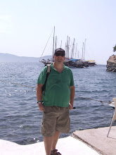
Am I Nearly There

Ready For The Off - Lands End 9th May

On top of Shap Fell

Was I Glad to See This Sign - Devon was over
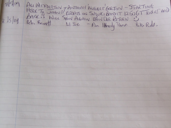
The Register Signed 9th May (note mistake in register as it says 8th)
No comments:
Post a Comment